How to Find Property Lines – Measure Land Accurately Without a Surveyor | GLandGo

How to Find Property Lines: A Complete Guide
Knowing how to find property lines is crucial for homeowners, real estate agents, and landowners. Whether you’re planning to build a fence, buy a new lot, or confirm your land boundaries, understanding where your property starts and ends can prevent legal issues and disputes.
Thanks to modern technology, you no longer need to hire a professional surveyor. With a smartphone and the GLandGo GPS Fields Area Measure app, you can measure property lines precisely on your own — anytime, anywhere.
1. Start with Your Property Documents
The first step in finding your property lines is reviewing your deed or plat map. These documents contain detailed boundary descriptions, dimensions, and sometimes even GPS coordinates. Understanding this information gives you a starting reference for your property measurement.
2. Identify Physical Markers
Walk around your land and look for visible property markers — metal pins, fences, walls, or posts that define the border. These indicators can help, but over time they may shift or be removed, so relying on them alone can be inaccurate.
3. Use GPS to Find Property Lines Without a Surveyor
In the past, people needed to hire licensed surveyors to determine exact boundaries — an expensive and time-consuming process.
Today, you can learn how to find property lines using GPS with the help of mobile apps like GLandGo, achieving professional-grade accuracy without external help.
4. Measure Your Property with GLandGo
GLandGo – GPS Fields Area Measure is a powerful, cross-platform GPS tool designed for property owners and professionals alike.
It lets you accurately measure land area, distance, and perimeter directly on your phone or tablet — no special equipment needed.
Why Choose GLandGo for Property Measurement
- 📏 Precise GPS Measurement: Mark your property lines directly on a satellite map and get accurate readings instantly.
- 🖼️ Photo Measurement Mode: Capture photos of your land with measurement lines overlaid — perfect for visual property records.
- 🔗 Easy Weblink Sharing: Share your measurements online through a simple link, so contractors, buyers, or neighbors can view your data easily.
- ☁️ Cross-Platform Access: Use GLandGo on Android, iOS, or web — your data stays synced across all devices.
- 👤 No Professional Surveyor Needed: Save time and money by doing accurate measurements yourself.
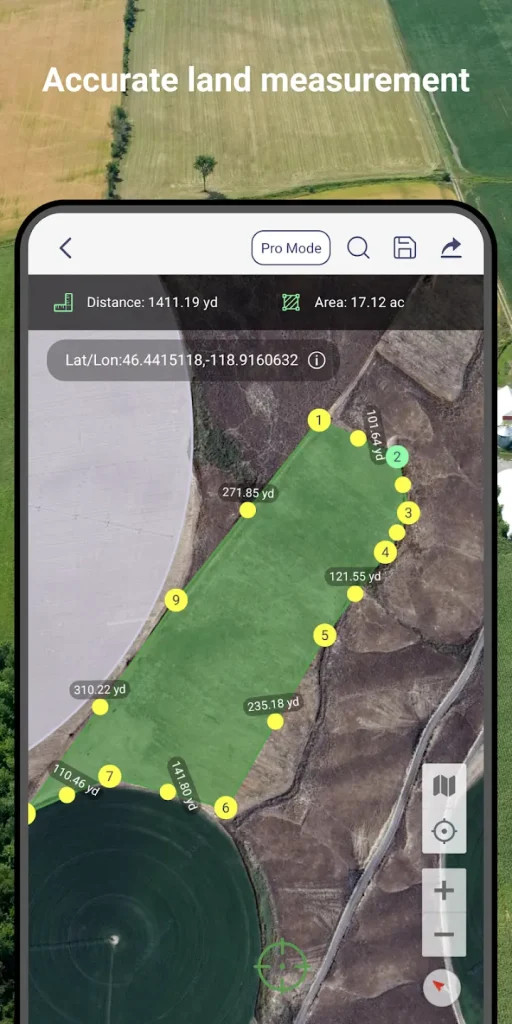
With GLandGo, you can handle all basic surveying tasks independently — ideal for property owners, farmers, and real estate professionals who want full control of their land data.
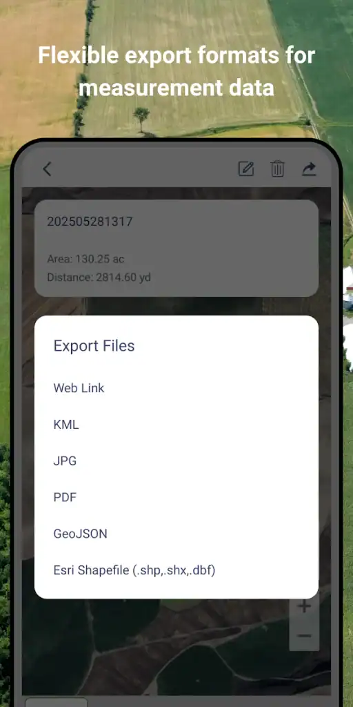
5. Save, Share, and Revisit Your Projects
Once your property lines are measured, GLandGo allows you to save and export your results with just one tap. You can share interactive maps online, attach images, and update your measurements anytime. This makes it a great tool for collaborating with real estate agents, builders, or land buyers.
6. When to Hire a Professional Surveyor
For legal property disputes or official documentation, a licensed surveyor may still be necessary. However, for everyday use, fencing, or general verification, GLandGo provides all the accuracy most users need.
Conclusion
If you’ve ever wondered how to find property lines quickly and affordably, GPS technology makes it easier than ever. With GLandGo, you can measure, visualize, and share your property boundaries yourself — no surveyor required.
Start mapping your land today!
👉 Download GPS Fields Area Measure – GLandGo and discover how easy it is to measure and share your property lines accurately.

